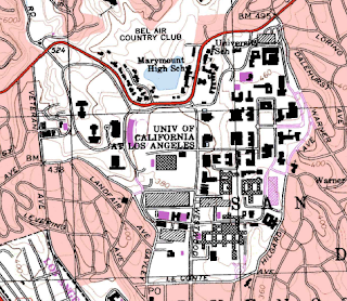
2. The names of adjacent quadrangle are Canoga Park, Van Nuys, Burbank, Topanga, Hollywood, Venice, and Inglewood.
3. The first quadrangle was first created in 1966.
4. The North American Datum of 1927 (horizontal) and the North American Datum of 1983 (vertical) were used to create this map.
5. The scale of this map was 1:24000.
6. Scale conversions:
a) 5 centimeters on the map is approximately equivalent to 1200 meters on the ground.
b) 5 inches on the map is approximately equivalent to 1.89 miles on the ground.
c) 1 mile on the ground is approximately equivalent to 2.64 inches on the map.
d) 3 kilometers on the ground is approximately equivalent to 12.50 centimeters on the map.
7. The contour interval on the map is 20 feet.
8. The approximate geographic coordinates for:
a) the Public Affairs Building is N 34˚04'30", W 118˚26'10" or (34.08˚, -118.44˚)
b) the tip of the Santa Monica Pier is N 34˚00'25", W 118˚30'0" or (34.01˚, -118.50˚)
c) the Upper Franklin Canyon Reservoir is N 34˚07'25", W 118˚24'28" or (34.12˚, 118.41˚)
9. The approximate elevation of:
a) the Greystone Mansion is about 560 feet or 170.69 meters
b) the Woodland Cemetery is about 145 feet or 44.20 meters
c) the Crestwood Hills Park is about 1050 feet or 320.04 meters
10. The UTM zone of the map is zone 11.
11. The UTM coordinates for the lower left corner of the map are 3763000m N, 372000m E.
12. There are 1000000 square meters contained within each square of the UTM grid lines.
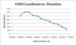
13. Elevation Profile from West to East.

| UTM coordinate | Elevation |
| 362000 E | 510 |
| 363000 E | 610 |
| 364000 E | 610 |
| 365000 E | 520 |
| 366000 E | 502 |
| 367000 E | 430 |
| 368000 E | 390 |
| 369000 E | 350 |
| 370000 E | 290 |
| 371000 E | 270 |
| 372000 E | 194 |
| 373000 E | 140 |
14. The magnetic declination is 14.8 degrees east.
15. Water flows north in the intermittent stream between the 405 freeway and Stone Canyon.
16. UCLA


Nice job 9.6/10
ReplyDelete9. c) Crestwood Hills Park - 634ft. = 193m.
14. 14 degrees
15. Water flows south.
also try to leave a space between answers to make it easier to read. Thanks.