In the year of 2009, numerous wildfires were prevalent throughout the state of California. One of the major ones was the Station Fire, which started in the Angeles National Forest before spreading out to cover a portion of the Los Angeles County. The staggering flames destroyed 209 structures and killed 2 firefighters. Reaching approximately 160,000 acres, itis currently the 10th largest in California history. Its duration reached approximately a month, lasting from August 26 to October 16.
Officials announced the cause of the fire to be arson. Because of the 2 deaths, a homicide investigation was also initiated. In addition, the U.S. Forrest Service was questioned as to why it did not contain the fire in the first 48 hours. This catastrophe both shocked and concerned residents and property owners alike. But although fires may sometimes result from human activity, wildfires themselves are not uncommon in California. The dry conditions and the occasional winds are ideal for fast-spreading fires. Furthermore, the warm climate tends to increase the lifespan of a fire. The Station Fire was certainly not the first of its kind seen in this state, although it was, by far, the largest in the area.
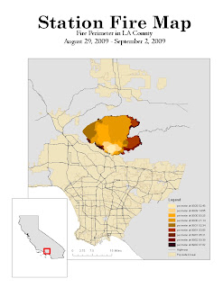
During the peak of its rage, the Station Fire covered multiple nearby communities, including La Canada Flintridge, Glendale, Acton, Le Crescenta, Littlerock, Altadena, and several neighborhoods within the City of Los Angeles. The slopes of Mount Wilson were also affected, as well as the areas around the Angeles Crest Highway. On my map above, the fire is depicted in various shades of orange and red. The initiation point of the wildfire, near the U.S. Forest Service ranger station in the Angeles National Forest, is displayed as a light orange spot. As the perimeter of the fire widens, the color darkens to a deep red. The legend displays the shades of colors that represent the area of the fire at a specific time on a specific day. This map displays the path of the fire between August 29th and September 2nd of 2009.
For my theme, I chose to display the populated areas of the Los Angeles County behind the shaded area of the fire. Also displayed are the major highways of the Los Angeles County. My thematic map shows how the fire spread geographically in comparison to the areas that were populated or used by people. It is evident that the fire lingered along the outer edges of the city while spreading deeply into the forest. The fire also managed to cross one major highway: the Angeles Crest Highway, which is mentioned earlier. From observations such as these, predictions or conclusions can be drawn. Perhaps the reason for the fire's path was because firefighters concentrated on preventing the flames from reaching deeper into the city and potentially causing expensive damage. Maybe the forest provided trees and materials to better fuel the fire. Comparing the path of the flames to the surrounding populated areas can reveal much information about the the fire.
This assignment demonstrates the many uses of thematic maps. During the fire, firefighters and newscasters alike used similar maps to track its movement. In addition, such maps provide different perspectives from which the data may be represented, and may therefore lead to revelations or insights about the event itself. Specifically, analysis can be performed to examine how the surrounding areas are affected by the phenomenon. Through such analysis, predictions may be made to help deal with similar problems. Thematic maps can assist us in making better decisions and taking smarter actions to benefit the community.
2009 California wildfires. Wikipedia. Web. 25 May 2010. http://en.wikipedia.org/wiki/2009_California_wildfires.
Mapshare. Web. 20 May 2010. http://gis.ats.ucla.edu//Mapshare/Default.cfm.
The National Map Seamless Server. Web. 20 May 2010. http://gis.lacounty.gov/eGIS/.
"Station Fire." CAL Fire. Web. 25 May 2010. http://cdfdata.fire.ca.gov/incidents/incidents_details_info?incident_id=377
Weikel, Dan (4 September 2009). "Angeles Crest Highway closed indefinitely because of fire". Los Angeles Times, 5 September 2009. Web. 25 May 2010. http://latimesblogs.latimes.com/lanow/2009/09/angeles-crest-highway-closed-indefinitely-because-of-fire.html.
No comments:
Post a Comment